

SL-LE 5 – Camino tradicional de Veneros a Llama
Hiking trails in the municipality of Boñar
Camino tradicional
Hiking Trails
SL-LE 5 : Camino tradicional de Veneros a Llama
Check the weather before you go…
Trail Information
Type of trail:
Circular.
Starting point:
Veneros.
Arrival point:
Llama.
Approximate duration:
Aprox. 1 h. 20 min. 6 km.
Slope:
Ascent 160 metres and descent 160 metres.
Type of trail:
Forest trail.
Recommended activity:
Pedestrian and cycling.
Difficulty:
Low.
Recommended time of year:
All year round, except with snow.
Maximum altitude:
1071 meters.
Minimum altitude:
971 meters.
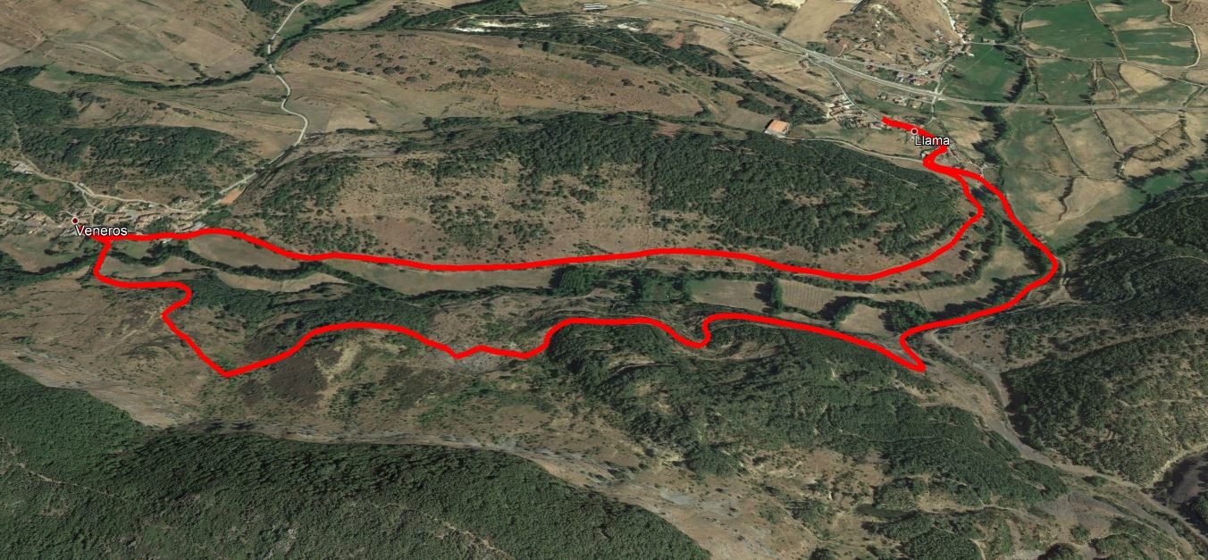
The “Camino tradicional de Veneros a Llama” has a high landscape and heritage value, mainly related to the old mining activity. Half of The trail runs parallel to the Collada stream, while the rest runs through the coal mines, now abandoned, and small plots of land used for livestock. Its circular path, 5.00 km long, crosses through meadows in the area and the nearby oak forest, providing a great variety of amazing scenery and landscapes. The trail can also be explored by bicycle, although it is not recommended, as the main interest of this route is the scenery, and it is best to do it on foot.
The traditional trail from Veneros to Llama starts from the southwest of the village of Veneros, reaches the village of Llama and returns to Veneros. Although it is a circular trail, it is preferable to start in Veneros and choose the path that starts crossing the village from west to east. This half of the trail runs along the right bank of the Collada stream, parallel to the stream and the livestock farms that still preserve the traditional constructions, such as enclosures, or sebes. The starting point is in Bajera street, marked with an information panel at the beginning of the trail, which will contain all the information you need to follow this trail safely. The trail passes through Veneros and Llama on tarmac, while the rest of the trail is on a well-marked track, with a compacted surface and a sufficient width to allow vehicles to pass.
The first junction is just 100 metres away from the start. To continue our trail, we only have to hfollow the directions shown by the directional arrows, ignoring the new streets that appear on the left hand side. The next junction is 1,400 metres from the starting point, formed by a split in the trail, although it is not clearly visible. Once you have passed this point, continue along the trail until you reach the village of Llama, which is signposted with an information panel indicating the start/end of the route. After a kilometre of ascent from the village of Llama, you will reach the abandoned mines, which, together with the landscape and the meadows for mowing and grazing cattle, are the main attraction of this trail. At this point you will find a poster that provides a complete explanation of the importance of these mines in the history of these regions located at the foothills of the Cantabrian Mountains. After a walk of about 3 kilometres from Llama, along the left bank of the river Colle, you will return to the starting point in Veneros.
It is advisable to bring warm clothing, comfortable hiking shoes, water and food as well as sunscreen.
It is also advisable to take binoculars and a camera to see and record the existing great variety of landscapes and species of fauna and flora.
Other places of interest are a visit to the silica quarry, a walk through the valley of the cherry trees, a visit to the fountain and the Gorgorita mill.
Photos of the trail


What are we to rocks and mountains?
Explore other great hiking trails here!!
PRC-LE 55
Ascensión a Pico Cueto
PRC LE-56
Por el Río Porma
PRC-LE 57
Las Ermitas
PRC-LE 58
Adrados to vozmediano
PRC-LE 59
Por Valdehuesa
SL-LE 1
Cascada de Foces
SL-LE 2
Cota del Campillo
SL-LE 3
Literary Hike – Rucayo to Utrero
SL-LE 4
La ermita de san pelayo
SL-LE 5
C. tradicional – Veneros a Llama
SL-LE 6
Ruta por el Pinar de Villares
Trail with Water
Trail with Water