

SL-LE 6 – Ruta por el Pinar de Villares
Hiking trails in the municipality of Boñar
Pinar de Villares
Hiking Trails
SL-LE 6 : Ruta por el Pinar de Villares
Check the weather before you go…
Trail Information
Type of trail:
Circular.
Starting point:
Voznuevo.
Arrival point:
Voznuevo.
Approximate duration:
Aprox. 3 h. 50 min. 9 km.
Slope:
Ascent 530 metres and descent 530 metres.
Type of trail:
Forest trail.
Recommended activity:
Pedestrian and cycling.
Difficulty:
Low.
Recommended time of year:
All year round, except with snow.
Maximum altitude:
1071 meters.
Minimum altitude:
971 meters.
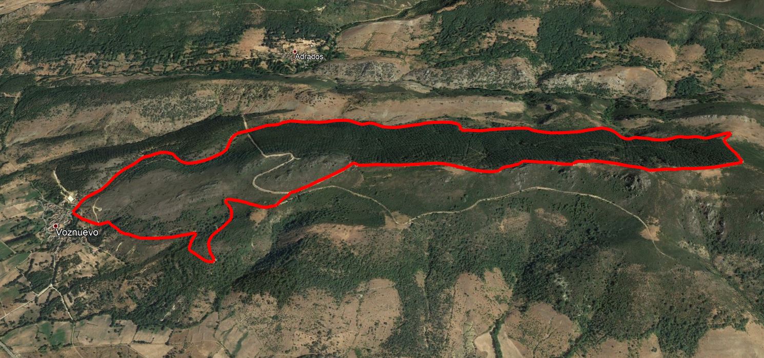
The trail starts and ends in the village of Voznuevo, going around the Pinar de Villares pine forest (Pinus sylvestris) until you reach the Peña de Cuervo, where you will have a magnificent view of the border between the plains of the Duero river basin and the Cantabrian Mountains.
The start of the trail, in the upper part of the village of Voznuevo, is well marked by an information panel, which in turn indicates the end of the trail, as it is a circular path. Head north to begin the first section, which climbs steadily, along a wide track, firstly through oak woods and then gradually towards the Pinar de Villares pine forest, an enclosed pine forest that will be on our right during this section of the trail. The trail consists of a continuous ascent until it reaches a hill, and from there it is the last stretch of a tough climb through a firebreak that ends near the Lacralagua peak, where there is an interpretative table that will help us to understand the configuration of the current landscape, as a result of traditional livestock activity and reforestation in the mid-20th century.
The second half of the trail runs at higher altitudes, for a stretch of about 2 kilometres from east to west, through an area of peaks between shrubs and small pines, where we can enjoy spectacular views of the Cantabrian Mountains and the plains of the Duero, to then begin a steep descent along well-marked trails through an area of oak forest (Quercus pyrenaica) that will lead us back to the town of Voznuevo.
The orientation on the path is very simple because this is a route that does not change. Is is a straightforward trail with little margin for error. There is a considerable range of elevations along the route, between 1,076 metres at Voznuevo and 1,545 metres at Peña del Cuervo, with a cumulative ascent of slightly more than 500 metres. The ascent, leaving the Pinar de Villares pine forest to our right, is constant for approximately 4 kilometres, with bearable slopes but which become steeper in the final stretch and will require greater effort, with slopes of over 25% in the last 300 metres of the ascent.
It is advisable to bring warm clothing, comfortable hiking shoes, water and food as well as sunscreen.
It is also advisable to take binoculars and a camera to see and record the existing great variety of landscapes and species of fauna and flora.
Other places of interest are a visit to the silica quarry, a walk through the valley of the cherry trees, a visit to the fountain and the Gorgorita mill.
Photos of the trail
What are we to rocks and mountains?
Explore other great hiking trails here!!
PRC-LE 55
Ascensión a Pico Cueto
PRC LE-56
Por el Río Porma
PRC-LE 57
Las Ermitas
PRC-LE 58
Adrados to vozmediano
PRC-LE 59
Por Valdehuesa
SL-LE 1
Cascada de Foces
SL-LE 2
Cota del Campillo
SL-LE 3
Literary Hike – Rucayo to Utrero
SL-LE 4
La ermita de san pelayo
SL-LE 5
C. tradicional – Veneros a Llama
SL-LE 6
Ruta por el Pinar de Villares
Trail with Water
Trail with Water