

SL-LE 2 – Cota del Campillo
Hiking trails in the municipality of Boñar
Cota del Campillo
Hiking Trails
SL-LE 2 – Cota del Campillo
Check the weather before you go…
Trail Information
Type of trail:
Linear.
Starting point:
Porma Dam.
Arrival point:
Porma Dam.
Approximate duration:
Aprox. 1 hour and 25 minutes. 4,1 km.
Slope:
Ascent 200 metres and descent 10 metres.
Type of trail:
Forest trail.
Recommended activity:
Pedestrian and cycling.
Difficulty:
Low.
Recommended time of year:
All year round, except with snow.
Maximum altitude:
1071 meters.
Minimum altitude:
971 meters.
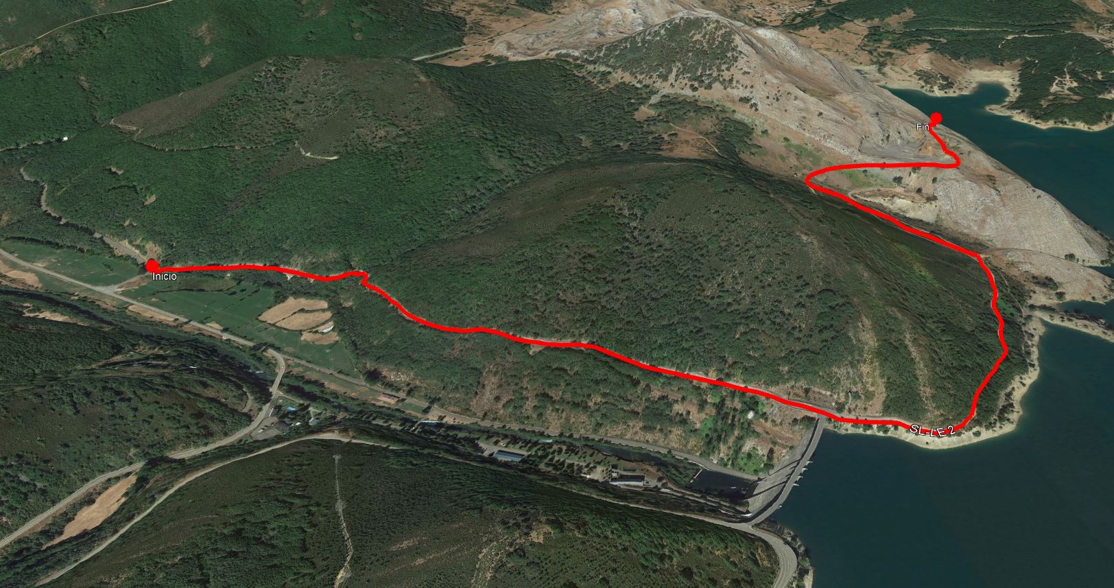
The Cota de Campillo (La Cantera) trail is located in the area around the Porma Dam. Its route, of just over 6 km, offers the visitor privileged views of the Cantabrian Mountains in the upper basin of the Porma River, the Pardomino Forest, the oak grove located in the lower part of the slope, and the holm oak grove in the upper area, without requiring a great physical effort. The route ends at a small quarry that was used for the construction of the dam, although if you climb a little further you will reach a viewpoint with an exceptional panoramic view over the valley and the dam. In addition, the state of the terrain means that a good part of the trail can be enjoyed by bicycle, although it is advisable, as the main interest of this route is the scenery, to do it on foot.
The Cota de Campillo (La Cantera) trail starts next to the cemetery located at the crossroads of Valdehuesa and the road to the Puerto de San Isidro. The start is marked by an information panel at the beginning of the trail. It runs along a deteriorated road, with loose gravel, which resembles a forest track, up to the wall of the Porma Dam.
The dam is located 1.3 km from the start, although its presence will mark the entire journey. Once you have reached this point, one of the main attractions of the trail becomes visible, the views of the upper basin of the Porma and the enormous sheet of water formed by the reservoir. It also changes the road surface, changing to a forest trail.
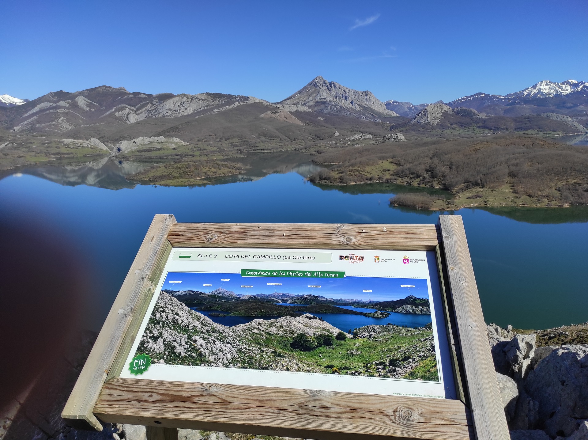
During the ascent, you will see an oak grove on the left and a body of water on the right. When we reach kilometre 2.4 of the route, we will see La Cantera, which consists of a stone quarry used in the construction of the dam. From this point, the trail goes on for a few more metres, off the path between limestone rock with paint marks, until it reaches the highest point where there is another panel with information about the place and the fantastic views, indicating the end point of the trail. Finally, we will return along the same itinerary.
It is advisable to bring warm clothing, comfortable hiking shoes, water and food as well as sunscreen.
It is also advisable to take binoculars and a camera to see and record the existing great variety of landscapes and species of fauna and flora.
Photos of the trail


What are we to rocks and mountains?
Explore other great hiking trails here!!
PRC-LE 55
Ascensión a Pico Cueto
PRC LE-56
Por el Río Porma
PRC-LE 57
Las Ermitas
PRC-LE 58
Adrados to vozmediano
PRC-LE 59
Por Valdehuesa
SL-LE 1
Cascada de Foces
SL-LE 2
Cota del Campillo
SL-LE 3
Literary Hike – Rucayo to Utrero
SL-LE 4
La ermita de san pelayo
SL-LE 5
C. tradicional – Veneros a Llama
SL-LE 6
Ruta por el Pinar de Villares
Trail with Water
Trail with Water